Descriptions of All Utilities Menu commands in InfoSWMM.
- Locate - The Locate command is used to find a node/pipe/element by ID within an InfoSWMM project. This function is also available from the Model Explorer - Attribute Tab toolbar
 . See: Locate
 - Change ID - The Change ID command allows the user to change the InfoSWMM database identification for any element from one value to another (as long as the new value for that element is unique). Merely select the Desired Element Type to change, type in the Old ID then the New ID. Clicking Apply will change the ID for that element. Click here to learn more.
- Pipe Invert - To verify the invert order of gravity mains, go to the InfoSWMM button, Utilities menu and select Pipe Invert Order. Select any of the commands, and then the user can either select pipes individually or drag a window across all desired elements. Once the pipes have been selected, right mouse click and choose the Enter option or hit the Enter key on your keyboard.
- Connectivity - The connectivity feature has many elements that assist the user in ensuring that connectivity is established prior to a model being run. It is important to note that connectivity is required for InfoSWMM to run a hydraulic simulation. Click here to learn more.
- Network Review/Fix - The Network Review/Fix Tool is a comprehensive network drawing examination and correction application for use in constructing reliable, credible working models ready for analysis. It offers users functionality to quickly identify and correct network topology problems and data flaws that may arise from digitizing a model or building it using pre-existing GIS and CAD datasets. See: Network Review/Fix Tool
- Database - The database feature allows the user to utilize database management from within InfoSWMM to find and correct database flaws or problems. Click here to learn more.
- Recall - The recall command (or Undelete) allows the user to recall a deleted pipe or node from the project database. It is important to note that when a record is deleted from a database, it is only "marked" for deletion (unless the user has turned on the Auto Database Packing feature in the Project Preferences). Click here to learn more.
- Update DB from Map - This feature allows the user to recreate some or all of the project databases from the graphics in the InfoSWMM project from the project databases. Click here to learn more.
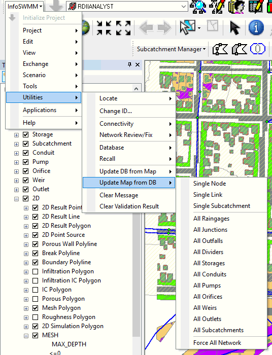
- Update Map from DB - This feature allows the user to regenerate the map graphics from the project database to ensure that the map view and the database contain the same data. Click here to learn more.
- Update Spatial Indexes - The Update Spatial Index command will help to speed up the map refresh in ArcMap. When there are tables joined to an InfoSWMM layer, ArcMap will not update the spatial indexes when those tables have been modified. The Update Spatial Indexes command will update the joined tables for an improved map refresh rate.
- Clear Message Board - Use this command to clear the InfoSWMM Message Board. The InfoSWMM message board displays messages, warnings and/or errors during, before and after an InfoSWMM simulation.
- Clear Validation Result - Clears the view from the Validation Message Board.
| Name | Description |
| Locate | The locate feature allows the user to search for a desired network element by its ID or by its description. Using the locate feature one can search for and automatically zoom in to a desired node, link, or Subcatchment. |
| Change ID | The change ID feature allows the user to change ID of any data element. |
| Connectivity | The connectivity submenu is used to verify network connectivity before running a simulation. When importing a model from an external data source (GIS, infrastructure inventory, other stormwater models, etc.), it is critical that the network representation be properly constructed (e.g.,each conduit is connected to exactly two nodes, each node is connected to at least one conduit). The features available under the connectivity submenu enable the user just to do that. |
| Network Review/Fix | The Network Review/Fix Tool is a comprehensive network drawing examination and correction application for use in constructing reliable, credible working models ready for analysis. It offers users complete functionality to quickly identify and automatically correct any network topology problems (e.g., disconnected nodes) and data flaws (e.g., duplicated conduits or nodes) that may arise from digitizing a model or building it using pre-existing GIS and CAD datasets. The Tool consists of many useful applications including: Trace Connected Nodes, Trace Network, Trace Upstream Network, Trace Downstream Network, and Locate Parallel Conduits. |
| Database | The database tools submenu assists the modeler in maintaining and managing project databases. |
| Recall | The recall command is used to restore – or undelete – network components that have been deleted. |
| Update DB from Map | The update DB from MAP command is used to update the current project’s database tables based on the current state of the network drawing. |
| Update Map from DB | The update MAP from DB command could be used to redraw the current project’s network map based on Geometry Data ( i.e., X, Y coordinates of the elements) and the TO nodeand the FROM node information of conduits. |
| Clear Message Board | This feature enables clearing of the information currently displayed on the message tab of the message board. |
| Clear Validation Result | This feature enables clearing of the information currently displayed on the validation tab of the message board . |
Privileged and Confidential Communication: This electronic mail communication and any documents included hereto may contain confidential and privileged material for the sole use of the intended recipient(s) named above. If you are not the intended recipient (or authorized to receive for the recipient) of this message, any review, use, distribution or disclosure by you or others is strictly prohibited. Please contact the sender by reply email and delete and/or destroy the accompanying message.