Wet Wells in InfoSewer and H20Map Sewer
Wet-wells are nodes with storage capacity that can vary with time during an extended period simulation. The primary input properties for wet wells are:
· The bottom elevation where the wastewater level is assumed to be zero
· The minimum level, i.e., the lowest allowable wastewater level above the bottom elevation
· The maximum level, i.e., the highest allowable wastewater level above the bottom elevation
· The initial level above the bottom elevation
· The wet-well diameter
Wet-wells are required to operate within their minimum and maximum levels. A wet-well can be modeled as a constant diameter (cylindrical) where a representative diameter is specified as the diameter corresponding to the average wet-well area. In case a wet-well can not be adequately described by a representative diameter, InfoSewerH20Map Sewerallows you to define data for the stored volume as a function of depth of wastewater using a curve (see CURVE section). This allows wet-wells of any shape (variable cross-sectional area) to be accurately modeled.
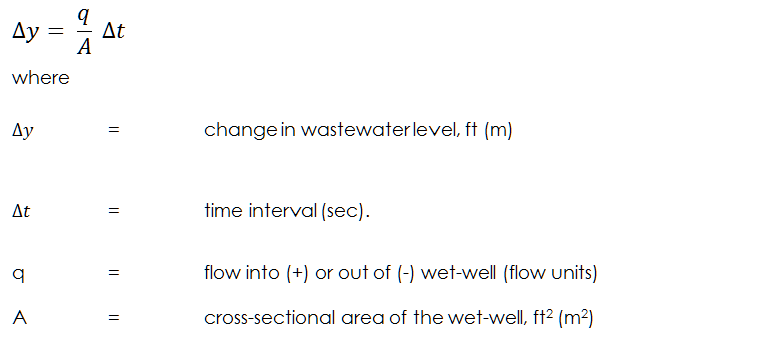
For an extended period simulation, InfoSewerH20Map Sewer accurately calculates the change in levels of a wet-well. The wastewater level is allowed to vary between the user-specified range of minimum and maximum permissible levels. If the wastewater level in the wet-well drops below the minimum level specified, the program automatically closes the pumps and no additional flow can exit the wet-well. InfoSewerH20Map Sewer models the change in wastewater level of a wet-well using the following equation:
The results computed for wet-wells for each time period of a simulation are:
· The wastewater level
· Grade
· Volume
· The volume percentage
· The overflow rate
