Descriptions of All Project Menu commands in InfoSWMM.
Title/Notes - Define the SWMM5 Title and Notes Headers
Calibration Data - Set up Calibration Data for your Network.
Import H2OMap Sewer - H2OMap Sewer has been deprecated by Innovyze as of 2018.
Import InfoSewer - Imports an InfoSewer Network.
Import - Imports a Network
Change Project Spatial Reference - Change the Spatial Reference of the InfoSWMM Map

| Name | Description |
| Title/Notes | Using this command, the modeler can edit notes or a write up that s/he wishes to be used as a title. |
| Calibration Data | This command opens a dialog for entering/registering calibration files. |
| Import H2OMAP Sewer | The command to import H2OMAP Sewer project in to InfoSWMM. |
| Import | The command to import H2OMMAP SWMM project in to InfoSWMM. |
| Import InfoSewer | The command to import InfoSewer project in to InfoSWMM. |
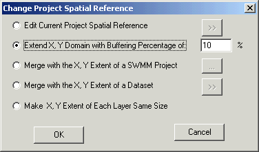
| Change Project Spatial Reference | The spatial reference of a data element in geodatabase can not be further modified once created in ArcGIS and new features can not be inserted if it's coordinates are beyond X, Y Domain of the spatial reference. InfoSWMM provides, the Change Project Spatial Reference, a very powerful tool to overcome this limitation of ArcGIS. As shown in the dialog editor below, In InfoSWMM spatial reference of a project can be modified by either editing the current project's spatial reference, extending the X, Y Domain with buffering percentage, merging with the X, Y extent of SWMM project, merging with the X, Y extent of a dataset, or making the X,Y extent of each layer in the project of the same size. To launch the Change Project Spatial Reference dialog box, choose Change Project Spatial Reference from the Project pull down menu under the InfoSWMM Control Center -> InfoSWMM button.
|
Change Project Spatial Reference
The spatial reference of a dataset in geodatabase can not be further modified once created in ArcGIS and new features can not be inserted if it's coordinates are beyond X, Y domain of the spatial reference. InfoSewer provides a very powerful tool to overcome this limitation of ArcGIS.
In InfoSewer the spatial reference of a project can be modified by either editing current project's spatial reference, extending the X, Y domain with buffering percentage, or merging with the X, Y extent of a dataset.
To launch the Change Project Spatial Reference dialog box, click on the InfoSewer Button ![]() , browse to the Project menu and select the Change Project Spatial Reference option.
, browse to the Project menu and select the Change Project Spatial Reference option.

- Edit Current Project Spatial Reference: Use this to modify/edit the spatial reference of a current project.
- Extend X,Y Domain with Buffering Percentage: Use this to modify the spatial reference of a project by extending the X,Y domain with buffering percentage.
- Merge with the X,Y Extent of a Dataset: Use this to modify the spatial reference of a project by merging with the X,Y extent of a dataset.
- OK: Click on OK to accept changes to the spatial reference coordinates and close out of the dialog box.
- Cancel: Use this to cancel the selection and close out of the dialog box. Any changes and/or selections made will not be reflected in the project.
Privileged and Confidential Communication: This electronic mail communication and any documents included hereto may contain confidential and privileged material for the sole use of the intended recipient(s) named above. If you are not the intended recipient (or authorized to receive for the recipient) of this message, any review, use, distribution or disclosure by you or others is strictly prohibited. Please contact the sender by reply email and delete and/or destroy the accompanying message.