Groundwater Flow in InfoSWMM and InfoSWMM SA from the SWMM5 Hydrology Manual
Shown below is a definition sketch of the two-zone groundwater model that is used in InfoSWMM H2OMap SWMM InfoSWMM SA . The upper zone is unsaturated at a varying moisture content of θ. The lower zone is saturated and therefore its moisture content is fixed at the soil porosity h.
Shown below is a definitional sketch of the two-zone groundwater model that is used in InfoSWMM H2OMap SWMM InfoSWMM SA. The upper zone is unsaturated with a variable moisture content of θ. The lower zone is fully saturated and therefore its moisture content is fixed at the soil porosity ϕ.
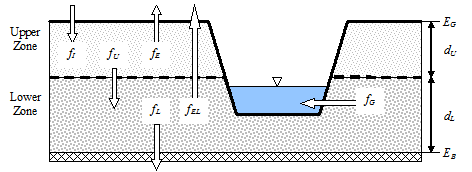
The fluxes shown in the figure, expressed as volume per unit area per unit time, consist of the following:
- fI infiltration from the surface
- fEU evapotranspiration from the upper zone which is a fixed fraction of the un-used surface evaporation
- fU percolation from the upper to lower zone which depends on the upper zone moisture content q and depth dU
- fEL evapotranspiration from the lower zone, which is a function of the depth of the upper zone dU
- fL percolation from the lower zone to deep groundwater which depends on the lower zone depth dL
- fG lateral groundwater interflow to the conveyance network which depends on the lower zone depth dL as well as depths in the receiving channel or node.

image00211 
image00313
After computing the water fluxes that exist at a given point in time, a mass balance is written for the change in water volume stored in each zone so that a new water table depth and unsaturated zone moisture content can be computed for the next time step.
The Groundwater Flow Editor dialog is invoked when the Groundwater property of a Subcatchment is being edited. It is used to link a subcatchment to both a parent aquifer and to a node of the conveyance system that exchanges groundwater with the subcatchment. It also specifies coefficients that determine the rate of lateral groundwater flow between the aquifer and the node. These coefficients (A1, A2, B1, B2, and A3) appear in the following equation that computes lateral groundwater flow as a function of groundwater and surface water levels:
QL = A1(HGW - HCB)B1 - A2(HSW - HCB)B2 + A3(HGW HSW)
where QL = lateral groundwater flow (cfs per acre or cms per hectare), HGW = height of saturated zone above bottom of aquifer (ft or m), HSW = height of surface water at receiving node above aquifer bottom (ft or m), and HCB = height of channel bottom above aquifer bottom (ft or m). Note that QL can also be expressed in inches/hr for US units.


The rate of seepage to deep groundwater, QD, in in/hr (or mm/hr) is given by the following equation:
QD = LGLR * HGW / HGS
where LGLR is the lower groundwater loss rate parameter assigned to the subcatchment's aquifer (in/hr or mm/hr) and HGS is the distance from the ground surface to the aquifer bottom (ft or m).
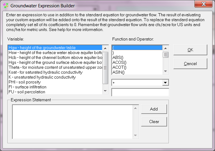
In addition to the standard lateral flow equation, the dialog allows one to define a custom equation whose results will be added onto those of the standard equation. One can also define a custom equation for deep groundwater flow that will replace the standard one. Finally, the dialog offers the option to override certain parameters that were specified for the aquifer to which the subcatchment belongs. The properties listed in the editor are as follows:
Aquifer Name
Name of the aquifer object that describes the subsurface soil properties, thickness, and initial conditions. Leave this field blank if you want the subcatchment not to generate any groundwater flow.
Receiving Node
Name of the node that receives groundwater from the subcatchment.
Surface Elevation
Elevation of the subcatchment's ground surface (ft or m).
Groundwater Flow Coefficient
Value of A1 in the groundwater flow formula.
Groundwater Flow Exponent
Value of B1 in the groundwater flow formula.
Surface Water Flow Coefficient
Value of A2 in the groundwater flow formula.
Surface Water Flow Exponent
Value of B2 in the groundwater flow formula.
Surface-GW Interaction Coefficient
Value of A3 in the groundwater flow formula.
Surface Water Depth (HSW - HCB)
Fixed depth of surface water above the receiving node's invert (ft or m). Set to zero if surface water depth will vary as computed by flow routing.
Threshold Water Table Elevation (EB + HCB)
Minimum water table elevation that must be reached before any flow occurs (feet or meters). Leave blank to use the receiving node's invert elevation.
Aquifer Bottom Elevation (EB)
Elevation of the bottom of the aquifer below this particular subcatchment (ft or m). Leave blank to use the value from the parent aquifer.
Initial Water Table Elevation (EB + HGW)
Initial water table elevation at the start of the simulation for this particular subcatchment (ft or m). Leave blank to use the value from the parent aquifer.
Unsaturated Zone Moisture
Moisture content of the unsaturated upper zone above the water table for this particular subcatchment at the start of the simulation (volumetric fraction). Leave blank to use the value from the parent aquifer.
Custom Lateral Flow Equation
Click the ellipsis button (or press Enter) to launch the Custom Groundwater Flow Equation editor for lateral groundwater flow (QL). The equation supplied by this editor will be used in addition to the standard equation to compute groundwater outflow from the subcatchment.
Custom Deep Flow Equation
Click the ellipsis button (or press Enter) to launch the Custom Groundwater Flow Equation editor for deep groundwater flow (QD). The equation supplied by this editor will be used to replace the standard equation for deep groundwater flow.
The coefficients supplied to the lateral groundwater flow equations must be in units that are consistent with the groundwater flow units, which can either be cfs/acre (equivalent to inches/hr) for US units or cms/ha for SI units.
 |
Note that elevations are used to specify the ground surface, water table height, and aquifer bottom in the dialog's data entry fields but that the groundwater flow equation uses depths above the aquifer bottom. |
 |
If lateral groundwater flow is simply proportional to the difference in groundwater and surface water heads, then set the Groundwater and Surface Water Flow Exponents (B1 and B2) to 1.0, set the Groundwater Flow Coefficient (A1) to the proportionality factor, set the Surface Water Flow Coefficient (A2) to the same value as A1, and set the Interaction Coefficient (A3) to zero. |
 |
Note that when conditions warrant, the lateral groundwater flow can be negative, simulating flow into the aquifer from the channel, in the manner of bank storage. An exception occurs when A3 ≠0, since the surface water - groundwater interaction term is usually derived from groundwater flow models that assume unidirectional flow. Otherwise, to ensure that a negative flow will not occur, one can make A1 greater than or equal to A2, B1 greater than or equal to B2, and A3 equal to zero. |
 |
To completely replace the standard lateral groundwater flow equation with the custom equation, set all of the standard equation coefficients to 0. |


